


Mount Doom
- Leo Micklem
- Oct 31, 2017
- 6 min read

This tale begins in the Wagon (Harry kindly leant me his car while he was exploring the South Island). I drove two and a half hours south of Auckland to Te Kuiti where I would gather the rest of the fellowship. Julian and Erik (Erik is new to my stories. He is a biomedical engineer from upstate New York who also plays frisbee) had spent the weekend on a rock climbing trip near Te Kuiti and had been dropped there by another climber to be collected. When I arrived, they were eating some dinner at a picnic bench while their tents dried. Erik was telling me that he had managed to leave his wallet in the other rock climber’s car and so he wouldn’t be able to drive as he didn’t have his licence with him. After a few minutes, an elderly lady climbed out of her car which was parked very close to us and said that she couldn’t help but over hear that Erik had lost his wallet. She had assumed that he had hitch hiked down and was going to give us her address so that we could camp there if we needed to. Once we explained that all was well she asked where we were all from and when she heard I was Irish she asked if I was into rugby. I said that I followed it alright to which she responded ‘Well I’ve got Stanley Meads, brother of Colin Meads in the car. Would you like to meet him?’. (Colin Meads is often referred to as one of the greatest All Blacks of all time, certainly of the 20th century, and his brother Stanley was also an All Black with 30 caps). I jumped at the opportunity and went to meet the great man and to receive the counsel of Stanley. Despite being born in 1938, and playing rugby for New Zealand, he was in relatively good shape and told me that he remembered playing in Dublin. As we left Te Kuiti we saw there were posters of Colin and Stanley everywhere because they farmed sheep not far away.
The drive continued on for a further two hours before we reached Whakapapa (Wh is pronounced ‘f’ in the Maori language) under the cover of darkness. We had already booked a campsite so pitched our tents and fell asleep. The hike we would be undertaking is known as the Northern Circuit which is one of the ‘Great Walks’ in New Zealand. The Abel Tasman is another of such ‘Great Walks’. Our plan was to begin the approximately 43km route at Mangatepopo (manga-te-popo meaning stream of rotten items) and then finish back in Whakapapa the next day. As it was ‘Great Walk season’ there was no parking allowed at the start of the track but it is possible to get a shuttle from Whakapapa to Mangatepopo. As you might expect, this is not cheap so we decided to get up at 5:30am so I could drive Julian and Erik to the start of the trail before driving back to get the first shuttle at 7:00am. It all worked out surprisingly well and we were underway by about 7:40am with views of Mt Ruapehu to our right.

This area, Tongariro National Park, is made up of three volcanoes, Mt Ruapehu, Mt Tongariro and Mt Ngauruhoe (na-ra-ho-ee), along with many other differing landscapes which I will talk more about later. The national park has been made more famous for being used for the filming of much of Mordor in The Lord of the Rings with Mt Ngauruhoe being the alter ego of Mount Doom. The first part of the circuit is known as the Tongariro Crossing and is supposed to be one of the best one day hikes in the world. Despite it being a Monday, it was still relatively busy but I was thankful we were not attempting it on a weekend in the middle of the summer! The path continued, slowly becoming steeper as we began to get views of Mount Doom. Gradually the surrounding area became less covered in shrubs and more covered in rocks. Eventually, the path began to rise so steeply that we had to zig-zag our way up until we came to a vast flat plane with Mt Tongariro on our left and Mount Doom on our right.


We crossed the plane, discussing whether to summit either or both of the peaks, before deciding it would be too dangerous to try summit Mount Doom but we’d have a go at Mt Tongariro. The ease of the flat plane was soon forgotten as our ascent continued. We came to another false peak before breaking off the track and heading along a ridge, between what was left of the snow. We made it to the peak before the summit but with all the melt water from the snow we decided that we had reached the summit as far as we were concerned! We took a quick group photo before returning to the track, admiring the views as we went.


As we came over the brow of the next hill we were stunned. This is probably one of the most amazing vistas that I have seen in New Zealand. The photos do not do it justice. Far out to the right was a seemingly endless rocky wasteland, below to our right a deep red curved cliff face,


below and to the front the brilliantly blue-green ‘Emerald Lakes’ and to the left the massive and yet still ‘Blue Lake’. One thing that really struck me was how still it was that day. There was next to no noise.
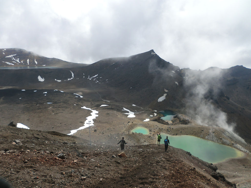
We slid our way down the sandy face, passing the ‘Emerald Lakes’ and swinging round to the left to go to the ‘Blue lake’. We stopped there for lunch, desperately tempted to go for a dip, but we quickly remembered that we were currently about 1700m above sea level and when you stop moving it gets rather cold rather quickly.
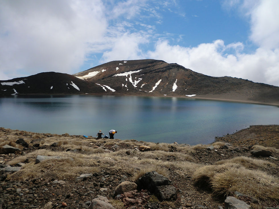

After a short pause, we doubled back to the ‘Emerald Lakes’, admiring a now-solid lava flow which was beautifully defined by the snow that had yet to melt.


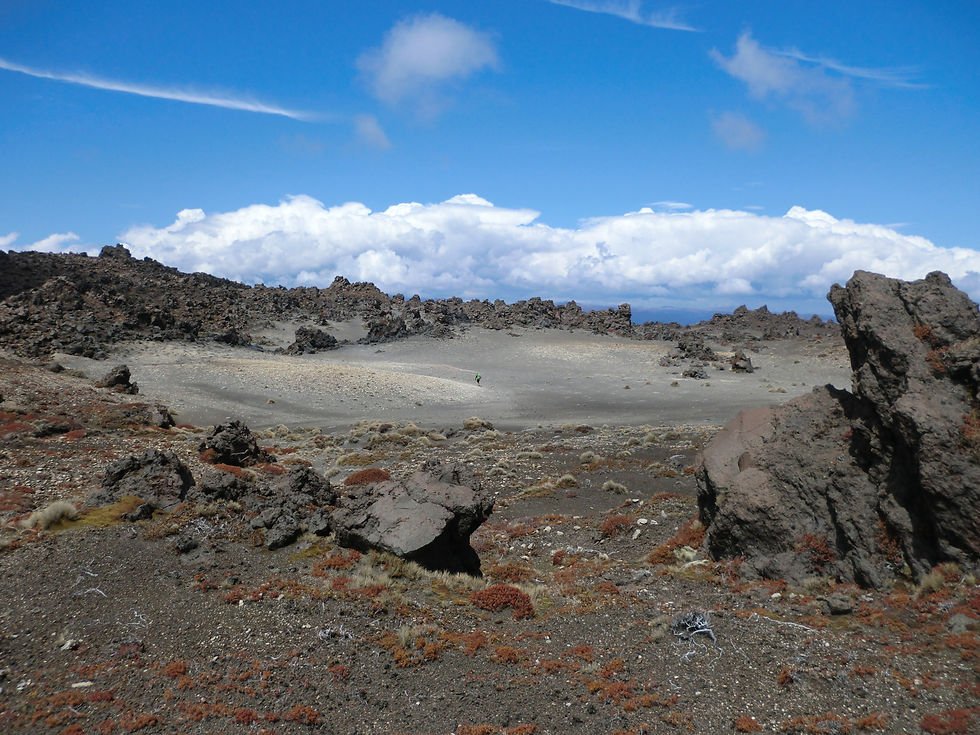
At this point we broke from the crossing and the crowds and were, more or less, alone while we hiked on, down towards the endless rocky wasteland we saw before. We followed one of the streams from the ‘Emerald Lakes’ above, now brilliantly white, as it carved steeply down until the land levelled off and we were amongst the rocks that were in fact much bigger than they had looked from above. I had great fun reciting how Father Ted explained perspective to Dougal to my North American friends, though I think it could be one of those you-had-to-have-seen-it sort of things.

The march continued, finishing off the final few kilometres of the 20km we had planned for the day. We followed a dried-up river for a while before coming across what were essentially black-sand sand dunes. Soon we reached the hut that we would be staying in for the night. Not a bad view for the evening.


We rested for an hour or so, playing cards, before we became restless and went exploring without our packs. We found a waterfall a short way from the hut and went to have a closer look. On our way, we spotted a rocky mound (The one in the back of the picture with the waterfall) so decided we’d go up that first. It gave such a freeing feeling being in that kind of environment.


We nipped down to the waterfall, top and bottom, and climbed through some holes in the soil that had formed from mudslides before heading back to the hut to cook up some dinner.


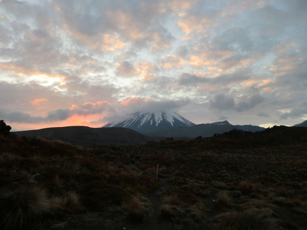
We were sharing the hut with about 10 other people. Most of them were taking the recommended four days to do the circuit so we didn’t expect to see them the next day as we had planned to set off early to do two day’s walking in one. We were treated to a gorgeous sunset behind Mount Doom before getting an early night.
We were up in time for sunrise as the hut warden had said that if it’s clear it is stunning but unfortunately it was foggy. It did mean we were underway by 7:30 once again and what a blessing that was. We headed down from where we were into a gorge and back up again. Just as we came out the cloud lifted enough to give us a stunning view of Ruapehu. The landscape, although still quite barren, was now made up mostly of gravel and small dotted shrubberies.

The first part of the morning was spent heading into and out of gorges, occasionally walking along the top of a hill, before we suddenly found ourselves in the middle of a forest. Almost immediately after climbing into the forest, we were climbing out, passing the next hut and back into a dry bog land.


As we finished off our roughly 45km adventure (our side tracks added to the total a little) we nipped off the track again to see the Tama lakes before we stopped for lunch, taking in how far we had just come (basically as far as you can see).


Just before we made it back to the car, we were treated to Taranaki Falls and a final 20 minutes in the woods to really round off a wonderful adventure. Boromir famously says in The Lord of the Rings ‘One does not simply walk into Mordor’ and he was right. It was a truly excellent two days of hiking, climbing, exploring, being amazed and generally having a great time. I can’t think of many better ways to spend Halloween than hiking around Mount Doom.


You can see all the photos from the adventure here.


Comments